Earth Exploration Satellite Service: learning about our planet
Much of the ECC's work that attracts widespread public attention is in high profile areas like mobile communications and broadcasting and some unlicensed applications like Wi-Fi. However, Europe's spectrum regulators are equally dedicated to services which are perhaps less well-known but which fulfil vitally important functions. One of these is the Earth Exploration Satellite Service (EESS), which provides a wide range of valuable information about the state of the Earth and its environment and processes, enabling a variety of applications valuable for scientists, policymakers and the public itself. CEPT is committed to protecting these important services, and to enabling new frequency ranges under the right conditions so that they can become even more useful.
There are three types of EESS spectrum use:
- EESS (passive), that is, non-transmitting instruments, only receiving naturally transmitted signals from the Earth (i.e. radiometers);
- EESS (active), that is, instruments transmitting a signal and receiving the echo from the Earth, i.e. radars such as synthetic aperture radars (SAR), radio altimeters, and scatterometers; and
- EESS communication links, which are necessary to operate the satellite, (i.e. telecommands and ranging (uplink); telemetry and ranging (downlink)), and to transmit back to Earth the payload data.
Protecting Earth sensing
'Passive' services are every bit as much a user of spectrum as the services which use transmitters. The ECC has been active by triggering − after years of extensive studies − a decision in the 2007 World Radiocommunication Conference to secure protection of some existing frequency bands for passive radio services. The ECC further decided to improve the security of these provisions in 2010 and 2011 by adopting a set of three Decisions (10)01, (10)02, (11)01. The aim was to establish mandatory limits to protect those bands from interference in contrast to the recommended limits approved at the ITU-Ri level. This action clearly shows that these important frequencies will be protected in the long-term, and that Europe recognises the societal and economic values of these spectrum-based applications.
These satellite services are typically non-commercial and gather vital measurement data on rain, snow and sea state, and soil moisture (the 10.6 GHz band). Similar services using a higher frequency (the 31.3-31.5 GHz band) gather information on temperature and other atmospheric parameters. Together with data from essential frequencies such as the 23.6-24 GHz band, this data informs scientists and policymakers about climate monitoring and the prediction of certain natural disasters, as well as more routine forecasting. ECC Decision (10)01 calls for mandatory limits to protect EESS (passive) from fixed and mobile services on the same frequency (at 10.6 GHz) and ECC Decision (10)02 deals with mandatory limits to protect EESS (passive) from unwanted emissions of fixed and mobile services operating at 30-31 GHz. ECC Decision (11)01 applies to the frequency band: 1400 to 1427 MHz, which is used to assess ocean salinity and soil moisture.
Looking forward
Now the CEPT/ECC is engaged in plans to expand the frequency range used for EESS (active and operational communication links) to enable it to take a step forward and increase its effectiveness. As this is an expansion for use by space stations, it is a worldwide issue, and so CEPT’s efforts are directed towards finding appropriate solutions for the 2015 World Radiocommunication Conference (WRC-15) Agenda Items 1.11 (related to EESS communication links) and 1.12 (related to EESS (active)).
Both Agenda Items were proposed for WRC-15 by CEPT countries, which see this as a good opportunity to add significantly to the understanding of Earth's topology and other short and long-term change observations (climate) as well as the response to, and mitigation of, threats from natural disasters.
Seeing through the clouds
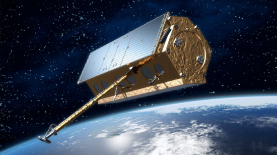
The big breakthrough is the high resolution images (< 25cm) which can be achieved with Synthetic Aperture Radars (SAR) planning for operation at around 9.6 GHz, combined with the fact that these frequencies can 'see' through the clouds. These satellites look similar to the existing TerraSAR-X shown in Figure 1 - this image shows the German SAR satellite TerraSAR-X which has been operating and providing data since 2009.
Figure 1: TerraSAR-X radar satellite currently in orbit (the next generation will look quite similar) © Airbus DS/Infoterra GmbH
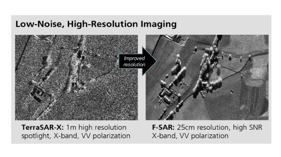
The picture resolution of the next generation of SARs will be in the same order of magnitude as for optical space-borne instruments. This is about much more than removing the minor curiosity of the occasional small cloud on 'Google Maps'. Figure 2 shows how the new technology creates a much clearer picture.
Figure 2: Comparison of current and future SAR resolution (Source: TerraSAR-X © DLR, Distribution Airbus DS/Infoterra GmbH)
Main applications of EESS (active):
- Disaster relief and humanitarian aid actions require ad hoc access to up-to-date geo information especially for remote areas of the globe. Safety of energy supply: to ensure sustainable oil and gas production, these sites need to be carefully monitored in terms of managing the extraction. In addition, vast pipeline networks require monitoring in terms of their integrity to avoid – or at least to detect – leakages and severe environmental pollution. For this, reliable and weather independent monitoring is required.
- City management and agricultural planning: especially for countries in the tropical regions suffering from substantial cloud coverage requires an affordable, reliable and weather independent mapping capacity.
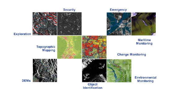
Figure 3: Application areas for SAR (DEM – Digital Elevation Model) (© DLR and Airbus DS/Infoterra GmbH)
Benefits from high-resolution EESS (active)
Satellite Remote Sensing is a challenging technology for acquiring up-to-date information under all weather and all light conditions over large geographical areas, even at variable scales, and is also the only practical way to obtain information from inaccessible regions. High precision geodetic references for SAR pictures enable coherent and interferometric long-term observations taken over months or years to reveal long term evolution of the Earth's features, e.g. landscapes, islands, coastlines, volcanoes, icebergs, etc. Report ITU-R RS.2178 states that: "One can improve prediction of the Earth system only through comprehensive, systematic Earth observation. Observing what is happening today and analysing what has happened in the past, is the key to understanding and predicting what will happen in the future."
Worldwide emergency management and disaster relief: the concept has evolved from pure post-accident activities to prevention, preparedness and mitigation of crisis through observation of trends and gradual developments on the Earth's surface, focusing on the role of pre-crisis activities too, in order to avoid or mitigate the consequences of a disaster.
During the 1990s, the World Bank estimated that an efficient warning system could decrease the impact of natural disasters by 240 billion US dollars. In 2011, the total estimated impact of natural and industrial disasters was 365 billion dollars. As stated by the World Disaster Report issued by the Red Cross in 2012: "...the number of people reported affected by natural disaster (209 million) in 2011 is the fourth lowest of decade, but is much higher than the minimum of 2006 (147 million). In 2011, almost 70 per cent of people reported affected were victims of floods."
The same year, the total number of people reported killed by natural disasters (drought/food insecurity, earthquakes, tsunamis, extreme temperatures, floods, forest/scrub fires, insect manifestation, mass movements, volcanic eruptions, windstorms, industrial and miscellaneous accidents) was about 37,000. The total number of people reported killed by natural disasters in the decade 2002-2011 was 1,240,000. In the same decade, the total number of people affected by the above mentioned phenomena was almost 2,690,000.
Technical requirements and Agenda Item 1.12 (WRC-15)
The next generation of satellite remote sensing will provide the highest possible resolution needed for global environmental monitoring which requires a corresponding transmission chirpii bandwidth of 1200 MHz. Resolution 651 (WRC-12) invites the ITU-R to study options for the extension of the current EESS (active) allocation in the band 9300-9900 MHz by up to 600 MHz anywhere within the frequency ranges 8700-9300 MHz and/or 9900-10 500 MHz.
Keeping Environmental Satellites in orbit; keeping them in touch
EESS of course needs frequency spectrum not only to look at the Earth as we describe above. We need to keep them in orbit, and to get the data they gather back to Earth.
Agenda item 1.11 with res. 650 (WRC-15) aims to identify a primary allocation for the Earth exploration satellite service (EESS) (Earth-to-Space) in the 7-8 GHz range.
EESS systems typically operate in non-geostationary, so-called 'sunsynchronous', orbits with near-polar inclinations. Earth stations that support these systems are located worldwide and are usually positioned at high latitudes to take advantage of the orbits of many EESS missions. Only when a satellite is in line-of-sight of an Earth station, can a communication link be established. The planning of communication operations between an Earth station and the satellite is dependent on capabilities of the on-board data system, the satellite power system, the observation goals, mission parameters, and the available communications capacity.
The EESS missions currently perform the functions of Telemetry, Tracking & Command (TT&C) in the S-band. The 2025-2110 MHz band is used to uplink the command and ranging signals, and the 2200-2290 MHz band is used to downlink the spacecraft telemetry and ranging signals. Both up/downlink bands are shared with the space research service (SRS) and the space operations service (SOS). The EESS missions perform the payload data download in either the 2200-2290 MHz or 8025-8400 MHz bands, depending on the data rate requirements.
Some future EESS missions will require larger bandwidth for TT&C in both directions (commanding and telemetry). The frequency coordination of these missions would be very problematic in the S-band, due to the congestion in this band.
Benefits from an EESS uplink in X-Band
An EESS (Earth-to-space) allocation in the 7-8 GHz range would allow some EESS missions with larger data rate requirements to use this new uplink allocation for TT&C in combination with the existing EESS (space-to-Earth) allocation in the 8025-8400 MHz band, thereby alleviating the congestion problem in the S-band, mitigating the frequency coordination problem, and eventually leading to a simplified on-board architecture and operational concept for these future EESS missions.
Stella Lyubchenko
ECO Spectrum Expert
Mark Thomas
Director of the ECO
With assistance from Elena Daganzo, European Space Agency, and Dr. Ralf Ewald, German Aerospace Center (DLR).
i ITU-R: International Telecommunication Union – Radiocommunication Sector
ii A 'chirp' is transmitted by sweeping an unmodulated carrier over a given bandwidth creating a short pulse of e.g. 50 µsec followed by a 100 µsec period of silence before the next sweep occurs.


