


Reaching new horizons – implementing digital terrain in SEAMCAT
The implementation of digital terrain in the software tool SEAMCAT is a game changer, but a complex task, writes Zeljko Tabakovic, ECO Spectrum Expert.
The Spectrum Engineering Advanced Monte Carlo Analysis Tool (SEAMCAT) is a software tool which can be used for modelling, simulation and analysis of sharing and compatibility scenarios between radiocommunications systems. The main purpose for the continuous development of SEAMCAT is to provide the ECC and its stakeholders with an open-source, free-of-charge software tool that allows them to perform co-existence studies. These can be used on the national basis supporting essential initiatives fostering developments in the telecommunication sector as well as in international fora to provide for widely accepted studies based on proven, well known methodologies making results easily comparable between different sources.
The importance of SEAMCAT for the CEPT is underlined by the management through the SEAMCAT Technical Group (STG), a permanent group chaired be the ECO.
A forward looking initiative of the Working Group on Spectrum Engineering, known as work item STG_07, calls for implementing digital terrain data to be used in combination with propagation models. In the last couple of years there has been a lot of SEAMCAT development relating to implementing digital terrain in the tool. Implementing this feature is quite a complex task, but it is a game changer for SEAMCAT, extending tool functionalities to the next level to cope with the ever-growing number and density of radio transmitters serving essential needs in modern societies.
When starting with implementing terrain there were some prerequisites which needed to be fulfilled to have meaningful implementation in SEAMCAT. These were:
- do not change the purpose and logic of the tool, i.e. keep the Monte-Carlo stochastic tool for sharing and compatibility simulation, for example, positions of Tx and Rx are randomly generated according to user settings with a geo-reference point enabling geo-positioning,
- enable the use of publicly available digital terrain data from different satellite missions (e.g. SRTM, ASTER, etc.), which user can download and put in the computer folder for the area of interest,
- develop readers of the most common formats of digital terrain data, where the user can use all digital terrain data available (not limited to public sources), determine which format of data to use in specific study and choose data precision raster,
- have in-tool embedded functionality to load data tiles and extract terrain height profile from Tx and Rx coordinates,
- use a SEAMCAT library of propagation model plugins to calculate propagation loss with terrain height profile in tools, simulation, interference analysis, EPPs, user defined plugins and integrate these functionalities seamlessly.

Figure 1: General classification of the propagation models
Implementation steps
STG recognised the complexity of the implementation of terrain functionalities in SEAMCAT and therefore decided for an incremental implementation of the functionalities which can be checked in subsequent test versions of the tool. For that purpose, work has been divided into several phases.
Overview of phases of implementation:
- Implementation of the Terrain Profile Tool – implementing terrain data reader, extracting terrain height profiles and calculation of path loss
- Implementation of digital terrain data for path loss calculation in SEAMCAT simulation and interference calculations
- Implementation of digital terrain data in SEAMCAT scenario and simulation
- Implementation in generic and cellular-like systems
- Calculation of transmission loss using terrain for victim system, interfering system, and interference links
- New features
- Extending terrain features to CommandLine, EPPs, External PMPs
- View and extract terrain height profiles data, export / import
- Adding Terrain settings to workspace settings, enabling exchange and loading workspaces with terrain settings among users
- Consistency checks for existence of terrain data (heuristic approach)
- Implementing multiple terrain data readers (4 DEM formats)
- Implementing support for terrain in multiple propagation models (4 PMP models supported)
- Additional features and enhancements
- Including more terrain data readers and propagation model plugins
- Improving void filling algorithm for terrain tiles
- Extending GUI displays to allow implementation of some mapping functionalities e.g. in simulation outline map overlay view functionality
- Performance enhancements in calculation speed, memory management and handling bottlenecks.
When implementing new functionalities, tests have been developed in parallel to proof the proper implementation. STG members tested features implemented in consecutive phases, comparing results with those implemented in other independent tools.
Overview of implemented features
The algorithms in SEAMCAT use the process of repeated random sampling of parameters which allows statistical modelling of diverse complex spectrum engineering and wireless compatibility scenarios. The tool assesses the potential interference between different radiocommunication systems that operate in shared, overlapping or adjacent frequency bands. It is not designed as a black box and users can design, adapt, and exchange system and simulation parameters, as well as view intermediate results of calculations and export results.
Digital terrain phases 1 to 3 have been implemented and are fully functional in SEAMCAT in a test version. SEAMCAT (from version 5.4.3A4 onwards) supports the digital terrain model in simulation and tools (terrain profile tool and test propagation model). The latest features are available in SEAMCAT test version 5.5.0 A3, which was released in February 2023, and there is further ongoing work and tests performed before new terrain features are released in an official version.
Below are screenshots of some of the implemented features relating to digital terrain. All information on the SEAMCAT itself, user documentation and a free download of the tool can be found on the following dedicated web page link. User documentation explaining how to use these new features and where to download DEM Data can be found in the document DEM terrain use in SEAMCAT.
a. Setting the environment
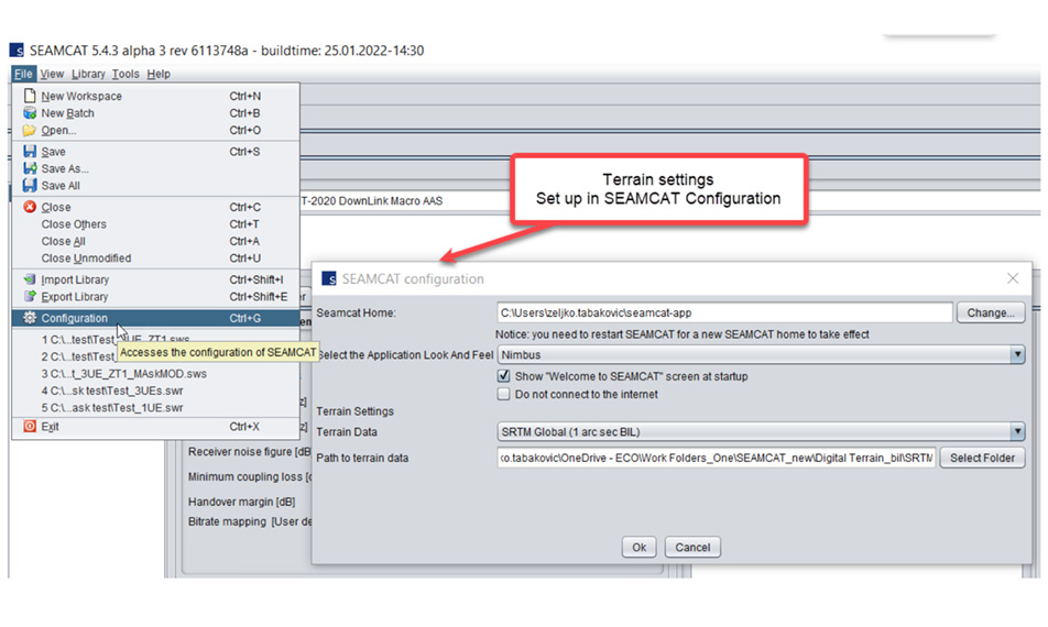
Figure 2: Terrain settings input in SEAMCAT configuration

Figure 3: Terrain settings in the simulation scenario
b. Running simulation and exploring simulation results

Figure 4: Enabling usage of terrain in propagation model and consistency check results

Figure 5: Outline of the simulation results
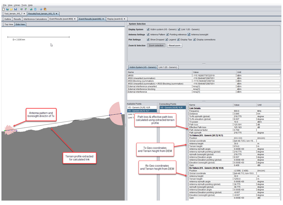
Figure 6: Event result showing terrain profiles of all links, geo data and related calculations
c. Examples of usage of terrain in SEAMCAT tools and processing plugins

Figure 7: Terrain profile tool showing terrain heights and propagation loss
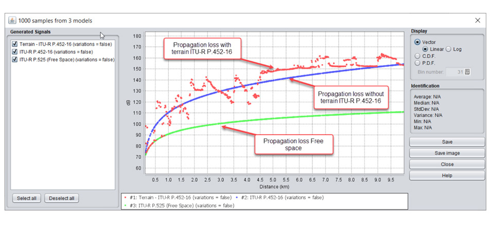
Figure 8: Test propagation models calculating propagation loss with and without terrain

Figure 9: Usage in plugins – extracting and exporting of terrain height profiles
SEAMCAT terrain implementation: In brief
SEAMCAT is a free-of-charge software tool which can be used for simulation of various sharing and compatibility scenarios between radiocommunications systems. In recent years SEAMCAT has been extended with a number of new features and built-in functions, enabling calculations using digital terrain. The terrain is functional in the SEAMCAT test version and works in sharing and compatibility simulations, including tools and plugins. The tool itself is platform independent and terrain functionalities are implemented in both desktop application and in the CommandLine application.
SEAMCAT can be downloaded here. Online user documentation for the tool is available on following link.
Users are welcome to test, use the tool and join the SEAMCAT community to contribute to the development of the software and its libraries. Be part of it!